A plan – searching for the source – in and out of water – skimming stones – lakes – joggers – horses – tea and cake
Since I first moved to Oxfordshire in 2009, I’ve always lived within a couple of miles of the River Thames. This was not a deliberate choice, but frankly around here it’s hard to avoid it.

Because of this, I’ve walked (and even commuted) along some stretches of the Thames Path National Trail a good deal. Over time I’ve developed a fascination with the other bits, where the path goes next after I turn off or turn back. Those little brown signs continue on and not knowing what’s around the bend of the river has niggled at me over the years.
This year that solidified into a decision to walk the whole darn thing, from source to sea. My brother Robin is always up for a challenge, and agreed to join me in my attempt. The practicalities of having 1) a busy job and 2) two small children that I like to hang out with (as well as 3) very poor physical fitness!) quickly ruled out an all-in-one, so instead we set a date of 11th October for our first day’s walking.
It was as I was planning this first stretch that I stumbled into the controversy of where exactly the Thames starts. The official source is at Trewsbury Mead, near Cirencester in Gloucestershire.
This is where the Thames Path starts and therefore where we’d be beginning our walk, but there’s another, more convincing candidate.
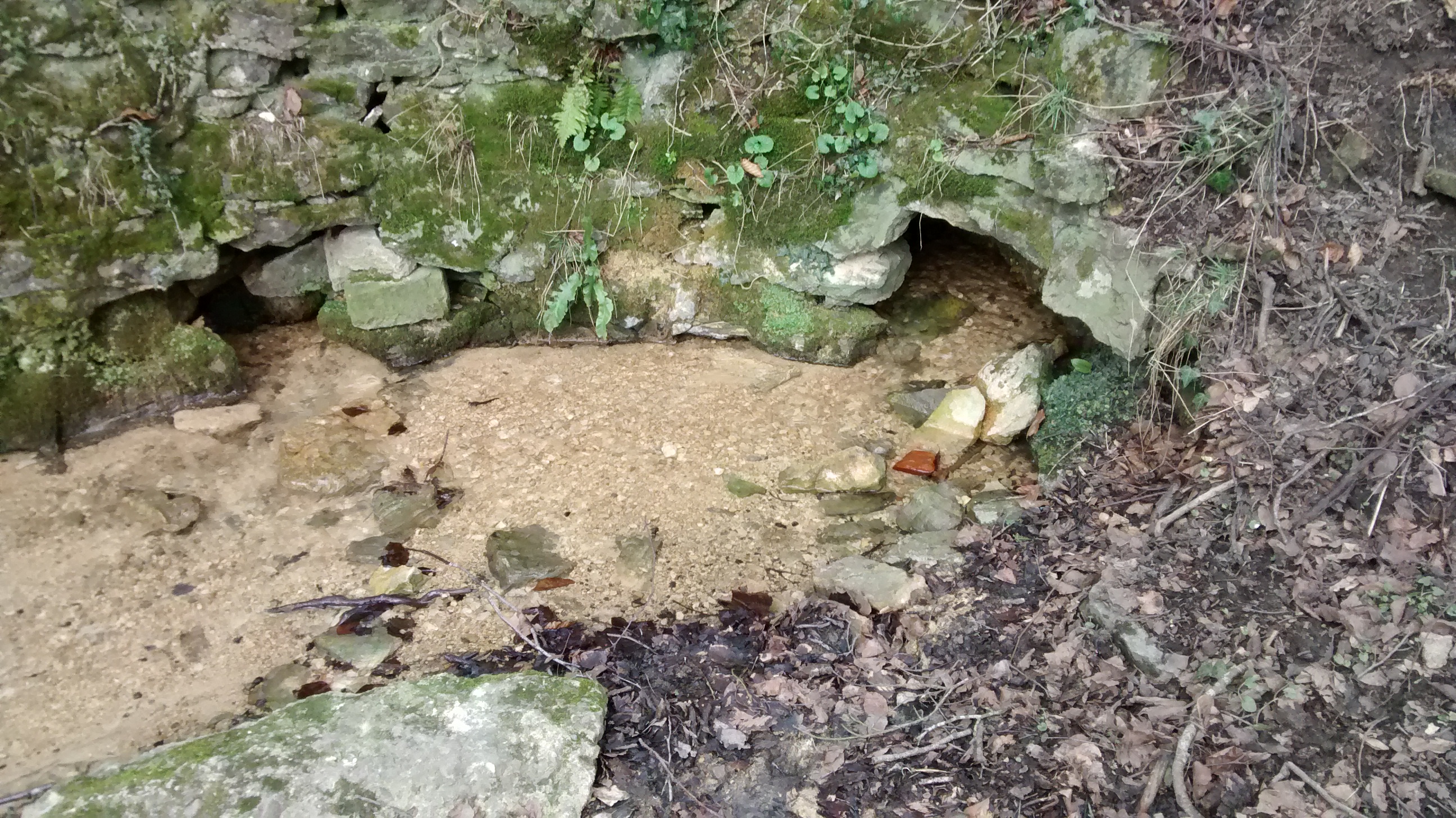
Seven Springs, near Cheltenham, is the source of the River Churn, a major tributary of the Thames. Seven Springs is significantly further from the mouth of the river than Trewsbury Mead, and a careful examination of the above images will show that it also has, y’know, water (Trewsbury Mead is dry apart from during serious floods – there was no water when we visited and it’s been a rainy few weeks). This might not seem important but if the alternative source at Seven Springs were accepted it would add around 14 miles of length to the Thames, which at present is only 5 miles shorter than the Severn, Britain’s longest river.

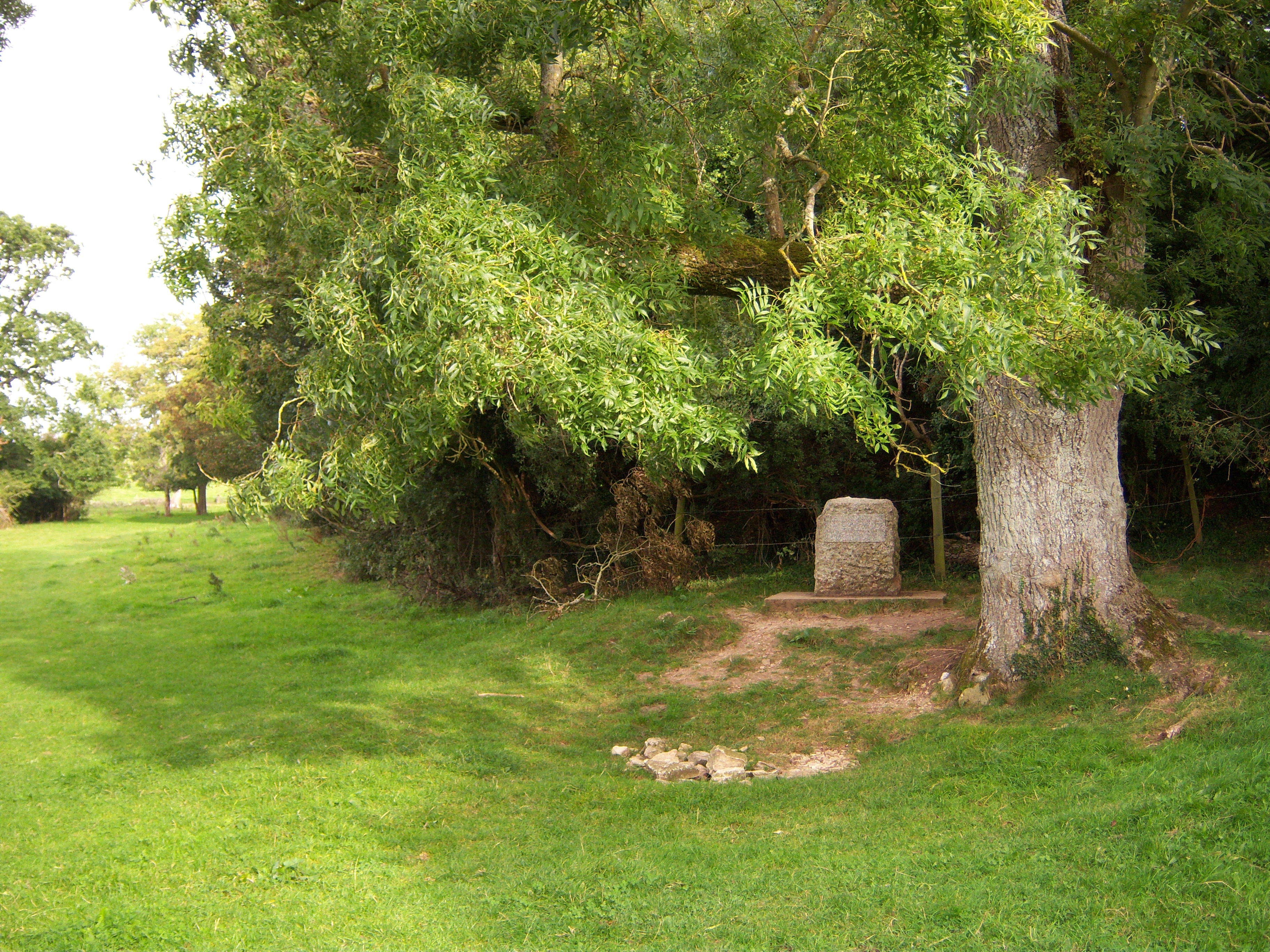
Having decided which source to start with, Robin and I sweet-talked Dan into getting up way too early in the morning in order to drive us out to the middle of nowhere to start our walk. You might assume there’d be a car park, perhaps some informative signage, maybe even a kitschy cafe at the start of the Thames Path. I certainly assumed that until I started my research. But no, there’s just a rock and a sign-post. There’s not even road access to the site itself, which is why our journey began at this random layby / driveway on Trewsbury Road, which is the closest you can get by car to the start of the Thames Path.

The picture’s not mine – we actually arrived in darkness. Dan zoomed off home to help JTA with the kids and Robin and I set out by the light of our head torches over the dark fields.
The paths were well marked, at least to start with, and it didn’t take long for us to find Thames Head.

About half an hour later I got very excited when the dry ditch we’d been walking along gained some water, but this turned out to be the first of many false alarms – for the first few miles the Thames is really just a ditch with occasional puddles.

Oh hey, the river. 
Psych!
About an hour in, we managed to find a stretch that was long and deep enough for Robin to skim a stone on. Much of this first day was characterized by noting “firsts” – first culvert, first bridge, first bridge with actual water under it (about three miles later), first weir, first cute Cotswold village, first ducks.

The path left the river for a while to take a detour through the pretty village of Ewen, then we spent a couple of peaceful miles following the river through a tunnel of trees before skirting the edge of Neigh Bridge country park and hitting the Cotswold Water Park. Our first indication that things were about to take a turn for the twee was multiple signs to “Lower Mill Estate”, then we caught sight of the ranks of slightly ghastly holiday homes, and then came the joggers.

Up until this point we’d only met one or two dog walkers as we rambled along, but on the stretch through the Cotswold Water Park we came across several groups of lycra-clad, toned people out jogging along the footpath, generally looking miserable. We lost track of the river as well a few times as the path threaded its way through the network of lakes (mostly from old gravel pits as I learnt later), so this stretch felt a lot more suburban than most sections of the upper Thames.
Eventually we were through though, and a short while later popped out the side of a weir into Ashton Keynes where an obliging bench provided the opportunity for a short rest and a snack.

At this point I stowed my phone away in my bag so didn’t take many pictures for the rest of the day (sorry, I only decided to write this up after we got home).
The next stretch of the path took us along more (but different) lakes, shortly after that two women out walking asked us for directions and we had to confess that other than being on the Thames Path we didn’t really know where we were. Fortunately they only wanted to know if they were nearly at the lake, which we were able to answer in the affirmative.
A short while later we reached North Meadow, which according to a board at the entrance is famous for impressive numbers of snake head fritillaries (a kind of flower) in the Spring. We had chosen to visit in the Autumn so all we saw was grass.
The last field before Cricklade was inhabited by a herd of horses, who seemed to be engaged in running round and round their field and didn’t care who or what might be in the way. We had to leap into the hedge twice to avoid being mown down – 8 or so horses galloping right at you is actually a little intimidating. At the end of the field we met the farmer leaning on the fence, impassively watching as we dodged his livestock. In response to our “hello” he seemed to think an acknowledgement of our recent peril was required: “We just put a new one in, the others are showing off”. So there you go.
Cricklade proved to be a charming town, where we stumbled into the highly-recommendable Cricklade Club for delicious raspberry blondies and a very welcome cup of tea (I might need to buy a flask before our next stretch). There Robin pointed out that I’d been limping for some time (I might need to buy better boots too) and that if we broke off there we could start our next leg with the Club’s excellent looking breakfast, and we agreed to call in the cavalry (Dan) for a rescue (lift home).

| Locations | Source -> Cricklade |
| Time | 6 hours |
| Distance | 12.2 miles |
| Cumulative Distance | 12.2 miles |
4 replies on “Thames Path 1”
“Herd of horses” didn’t sound right to me. I didn’t know what it should say, but I was confident it wasn’t “herd”, “flock”, or “shoal”…
…and found my way to the Farmers’ Almanac, which apparently has a website nowadays. It says that a group of horses is generically called a “team” or “harras”, or possibly a “string”.
It actually didn’t look right to me either but when I looked up the other options I decided I couldn’t pull any of them off – they all sounded way too pretentious for someone who’s not even really sure what jodhpurs are. Shall we just say “a bunch”?
[…] our first day‘s walking along the Thames Path, Robin and I had trouble finding any evidence of water for […]
I herd one of the horses whisper to another as they pased – I bet she gets the collective noun for us wrong when she talks of this day